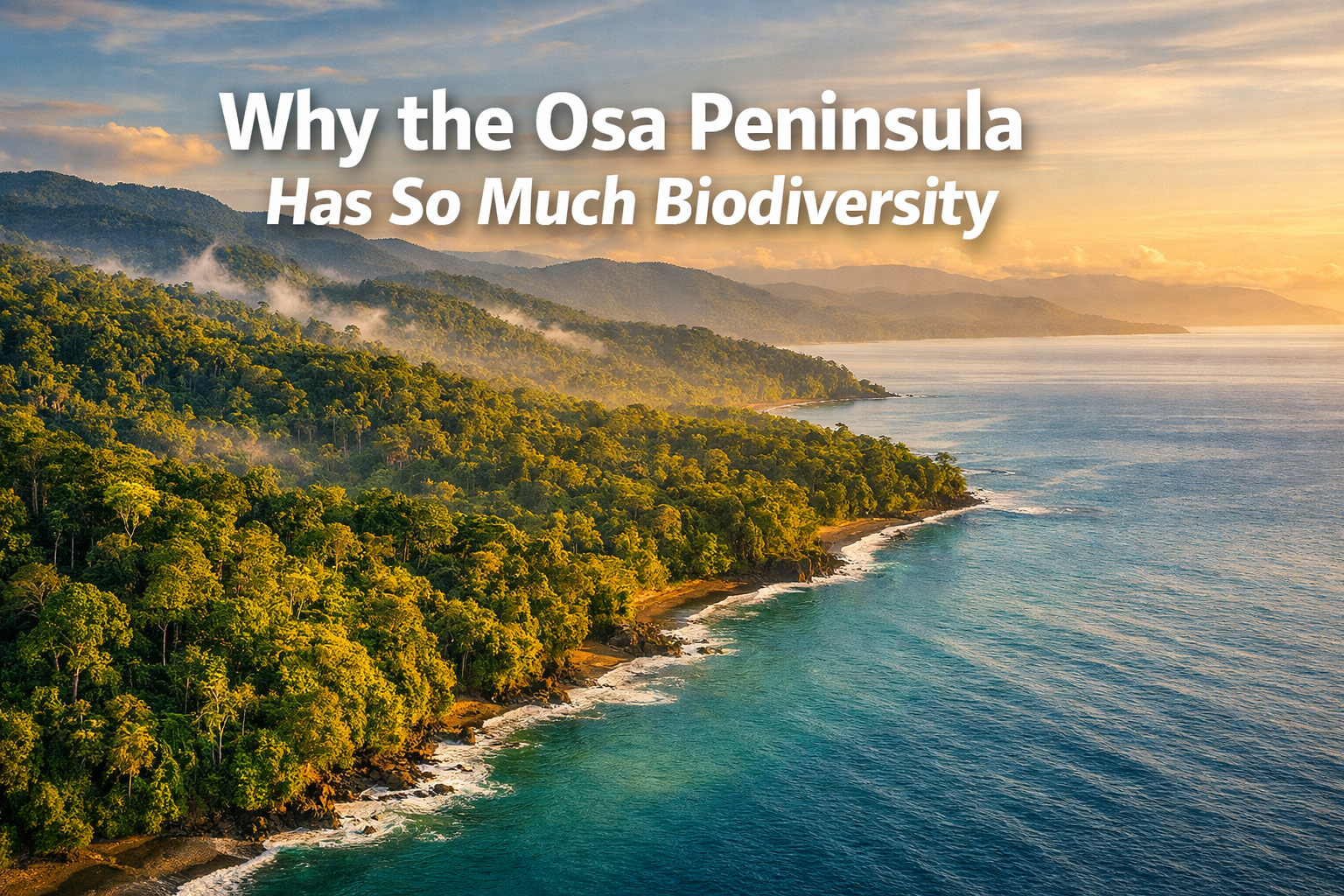
Why the Osa Peninsula Has So Much Biodiversity: A Field Guide to Costa Rica's Wildest Region
Last updated: April 23, 2026
Quick Answer
The Osa Peninsula holds 2.5% of the world's biodiversity on less than 0.001% of Earth's surface because of a rare geographic convergence: the largest remaining Pacific-slope mesic rainforest in Central America, a tropical fjord (Golfo Dulce), extensive mangrove systems, and an elevation gradient from sea level to 745 meters—all compressed into roughly 1,700 square kilometers. This creates overlapping habitat zones, microclimates, and ecological niches that support extraordinary species density, from lowland tapirs to pelagic sharks using coastal nurseries.
Key Takeaways
- Geographic convergence drives biodiversity: rainforest, tropical fjord, mangroves, and elevation gradients create overlapping habitat zones in a compact area
- Corcovado National Park protects the largest Pacific-slope mesic rainforest remaining in Central America—critical for species that require intact, wet lowland forest
- Golfo Dulce is one of only four tropical fjords on Earth, with deep, nutrient-rich waters supporting marine megafauna and confirmed migratory corridors to Cocos Island
- Seasonal rhythms shape wildlife behavior and photographic conditions: Green Season (May–November) brings rain, breeding activity, and dramatic light; Blue Season (December–April) offers calmer weather and marine mammal peaks
- Species density is unmatched—13 endemic amphibians, all four Costa Rican monkey species, scarlet macaws, Baird's tapirs, and over 500 tree species per hectare in some plots
- Conservation efforts since the 1970s reversed deforestation trends; 240,231 native trees planted in 2024 alone to restore the AmistOsa Biological Corridor
- Photographic access requires understanding habitat, timing, and ethical fieldcraft—this isn't a zoo; it's a working rainforest with real conditions
What Makes the Osa Peninsula a Biodiversity Hotspot?
The Osa Peninsula concentrates biodiversity because it sits at a rare intersection of ecosystems, climates, and evolutionary pressures. National Geographic called it "the most biologically intense place on Earth" in 2016, and the data supports that claim: 2.5% of global biodiversity on 0.001% of the planet's surface.[1]
Three factors converge here that don't overlap elsewhere in Central America:
- The largest Pacific-slope mesic rainforest remaining in the region, protected primarily within Corcovado National Park
- Golfo Dulce, a tropical fjord with depths exceeding 200 meters, creating a marine environment more typical of temperate latitudes
- Extensive mangrove wetlands—the largest on Central America's Pacific slope—serving as nurseries for marine species and transition zones for terrestrial wildlife
This isn't just about having a lot of trees. It's about habitat complexity compressed into a small area. When you move from the beach at Matapalo to the ridgeline trails above Drake Bay, you pass through multiple life zones in less than an hour's hike. Each zone supports species adapted to specific moisture levels, canopy structure, and microclimates.
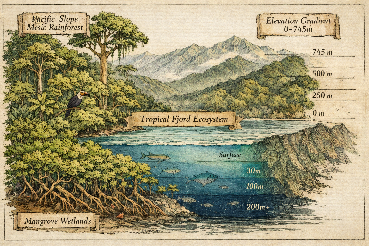
The Role of Elevation and Terrain
Elevation on the Osa ranges from sea level to 745 meters at Cerro Rincón. That's not dramatic by Andean or Himalayan standards, but in a tropical lowland context, it's enough to create distinct microclimates. Moisture-laden air from the Pacific rises against these ridges, cools, and drops rain—lots of it. Annual rainfall exceeds 5,000 millimeters in some areas, sustaining the mesic (consistently moist) conditions that many species require.
The terrain also fragments into valleys, ridges, and coastal plains, creating isolated pockets where populations evolve independently. This is why the Osa has 13 endemic amphibian species—frogs and salamanders that exist nowhere else on Earth.[2]
Fun fact: Golfo Dulce is so deep and sheltered that it maintains a stable thermocline year-round, allowing species like hammerhead sharks and bull sharks to use it as a nursery—behavior more common in temperate estuaries than tropical bays.
How Does the Osa Peninsula's Geography Explain Why It Has So Much Biodiversity?
Geography is the foundation. The Osa Peninsula juts into the Pacific Ocean at the southern tip of Costa Rica's Puntarenas Province, bordered by Golfo Dulce to the east and the open Pacific to the west. This position creates a buffer zone where marine and terrestrial ecosystems overlap.
Rainforest, Ocean, Mangroves, and Elevation Explained
The Osa's biodiversity depends on four interconnected systems:
Tropical lowland rainforest: Dominated by emergent trees like ceiba and espavel, with a closed canopy at 30–40 meters and an understory dense with palms, heliconias, and ferns. This is primary forest—old growth that has never been cleared—and it supports species that can't survive in secondary regrowth.
Golfo Dulce tropical fjord: Formed by tectonic activity, this deep-water gulf creates upwelling zones that bring nutrients from the ocean floor to the surface, feeding plankton blooms that attract manta rays, dolphins, and humpback whales. Scientists confirmed in March 2026 that Golfo Dulce serves as a critical nursery in the Cocos–Osa Swimway, a 535-kilometer migratory corridor linking Cocos Island's shark aggregations to mainland habitats.[5]
Mangrove wetlands: Red, black, and white mangroves line estuaries and river mouths, stabilizing sediment, filtering runoff, and providing shelter for juvenile fish, crocodiles, and wading birds. These are transition zones—neither fully marine nor terrestrial—and they support species adapted to brackish water and tidal flux.
Elevation gradient: From sea level to 745 meters, the Osa compresses multiple life zones into a compact area. Higher elevations receive more rainfall and cooler temperatures, supporting cloud forest species at the upper limits. Lower elevations stay warmer and drier (relatively speaking), favoring different plant and animal communities.
This layering creates edge effects—zones where two habitats meet—and edges are biodiversity hotspots. A scarlet macaw might nest in a rainforest emergent tree, forage in coastal almond groves, and drink from a mangrove creek, all within a few kilometers.
Why This Matters for Wildlife Photography
Understanding these systems helps you predict where and when to find species. Tapirs prefer lowland forest near water sources. Toucans move between fruiting trees in the canopy. Humpback whales calve in Golfo Dulce's calm waters from July to October and again from December to March (two separate populations). If you're shooting in the wrong habitat at the wrong time, you'll miss the shot—no matter how good your gear is.
<!DOCTYPE html>
<html lang="en">
<head>
    <meta charset="UTF-8">
    <meta name="viewport" content="width=device-width, initial-scale=1.0">
    <title>Osa Peninsula Seasons Comparison</title>
    <style>
        * {
            margin: 0;
            padding: 0;
            box-sizing: border-box;
        }
        .cg-element-container {
            font-family: -apple-system, BlinkMacSystemFont, 'Segoe UI', Roboto, Oxygen, Ubuntu, Cantarell, sans-serif;
            max-width: 900px;
            margin: 30px auto;
            padding: 20px;
            background: linear-gradient(135deg, #1a3a2e 0%, #2d5a4a 100%);
            border-radius: 12px;
            box-shadow: 0 8px 24px rgba(0,0,0,0.2);
        }
        .cg-element-title {
            text-align: center;
            color: #ffffff;
            font-size: 26px;
            font-weight: 700;
            margin-bottom: 25px;
            text-shadow: 2px 2px 4px rgba(0,0,0,0.3);
        }
        .cg-element-toggle-container {
            display: flex;
            justify-content: center;
            margin-bottom: 30px;
        }
        .cg-element-toggle {
            background: rgba(255,255,255,0.15);
            border-radius: 50px;
            padding: 6px;
            display: flex;
            gap: 6px;
            backdrop-filter: blur(10px);
        }
        .cg-element-toggle-btn {
            padding: 12px 32px;
            border: none;
            border-radius: 50px;
            font-size: 16px;
            font-weight: 600;
            cursor: pointer;
            transition: all 0.3s ease;
            background: transparent;
            color: rgba(255,255,255,0.7);
        }
        .cg-element-toggle-btn.cg-active {
            background: #ffffff;
            color: #1a3a2e;
            box-shadow: 0 4px 12px rgba(0,0,0,0.2);
        }
        .cg-element-content {
            background: rgba(255,255,255,0.95);
            border-radius: 10px;
            padding: 30px;
            min-height: 400px;
        }
        .cg-element-season {
            display: none;
        }
        .cg-element-season.cg-active {
            display: block;
            animation: cg-fadeIn 0.4s ease;
        }
        @keyframes cg-fadeIn {
            from { opacity: 0; transform: translateY(10px); }
            to { opacity: 1; transform: translateY(0); }
        }
        .cg-element-season-header {
            display: flex;
            align-items: center;
            gap: 15px;
            margin-bottom: 25px;
            padding-bottom: 15px;
            border-bottom: 3px solid #e0e0e0;
        }
        .cg-element-icon {
            font-size: 48px;
        }
        .cg-element-season-title {
            font-size: 28px;
            font-weight: 700;
            color: #1a3a2e;
        }
        .cg-element-months {
            font-size: 14px;
            color: #666;
            font-weight: 500;
        }
        .cg-element-section {
            margin-bottom: 25px;
        }
        .cg-element-section-title {
            font-size: 18px;
            font-weight: 700;
            color: #2d5a4a;
            margin-bottom: 12px;
            display: flex;
            align-items: center;
            gap: 8px;
        }
        .cg-element-section-icon {
            font-size: 20px;
        }
        .cg-element-list {
            list-style: none;
            padding-left: 0;
        }
        .cg-element-list li {
            padding: 10px 0 10px 30px;
            position: relative;
            color: #333;
            line-height: 1.6;
            font-size: 15px;
        }
        .cg-element-list li:before {
            content: "→";
            position: absolute;
            left: 8px;
            color: #2d5a4a;
            font-weight: 700;
        }
        .cg-element-highlight {
            background: #fff9e6;
            border-left: 4px solid #f4a261;
            padding: 15px;
            margin-top: 20px;
            border-radius: 6px;
        }
        .cg-element-highlight-title {
            font-weight: 700;
            color: #d97706;
            margin-bottom: 8px;
            font-size: 16px;
        }
        .cg-element-highlight-text {
            color: #555;
            line-height: 1.6;
            font-size: 14px;
        }
        @media (max-width: 768px) {
            .cg-element-container {
                padding: 15px;
                margin: 15px;
            }
            .cg-element-title {
                font-size: 22px;
            }
            .cg-element-toggle-btn {
                padding: 10px 20px;
                font-size: 14px;
            }
            .cg-element-content {
                padding: 20px;
            }
            .cg-element-season-title {
                font-size: 24px;
            }
            .cg-element-icon {
                font-size: 36px;
            }
        }
    </style>
</head>
<body>
    <div class="cg-element-container">
        <h2 class="cg-element-title">Osa Peninsula: Green Season vs. Blue Season</h2>

        <div class="cg-element-toggle-container">
            <div class="cg-element-toggle">
                <button class="cg-element-toggle-btn cg-active" data-season="green">Green Season</button>
                <button class="cg-element-toggle-btn" data-season="blue">Blue Season</button>
            </div>
        </div>

        <div class="cg-element-content">
            <div class="cg-element-season cg-active" id="cg-green">
                <div class="cg-element-season-header">
                    <div class="cg-element-icon">🌧️</div>
                    <div>
                        <div class="cg-element-season-title">Green Season</div>
                        <div class="cg-element-months">May – November</div>
                    </div>
                </div>

                <div class="cg-element-section">
                    <div class="cg-element-section-title">
                        <span class="cg-element-section-icon">☁️</span>
                        Weather & Conditions
                    </div>
                    <ul class="cg-element-list">
                        <li>Heavy afternoon rains (5,000+ mm annually in some areas)</li>
                        <li>Humid, lush forest with swollen rivers and waterfalls</li>
                        <li>Dramatic cloud formations and moody atmospheric light</li>
                        <li>Trails can be muddy; river crossings more challenging</li>
                        <li>Temperatures 24–30°C with high humidity</li>
                    </ul>
                </div>

                <div class="cg-element-section">
                    <div class="cg-element-section-title">
                        <span class="cg-element-section-icon">🦜</span>
                        Wildlife Activity
                    </div>
                    <ul class="cg-element-list">
                        <li>Peak breeding season for many bird species</li>
                        <li>Amphibians highly active (13 endemic species)</li>
                        <li>Scarlet macaws nesting in emergent trees</li>
                        <li>Insects abundant—critical for insectivorous species</li>
                        <li>Tapirs and peccaries more visible near water sources</li>
                    </ul>
                </div>

                <div class="cg-element-section">
                    <div class="cg-element-section-title">
                        <span class="cg-element-section-icon">📸</span>
                        Photographic Conditions
                    </div>
                    <ul class="cg-element-list">
                        <li>Soft, diffused light ideal for rainforest interiors</li>
                        <li>Dramatic storm light and rainbows after showers</li>
                        <li>Vibrant greens and saturated colors</li>
                        <li>Gear protection essential (rain covers, silica gel)</li>
                        <li>Early mornings offer brief clear windows before clouds build</li>
                    </ul>
                </div>

                <div class="cg-element-highlight">
                    <div class="cg-element-highlight-title">Best For:</div>
                    <div class="cg-element-highlight-text">Photographers seeking dramatic light, breeding behavior, amphibian diversity, and lush forest scenes. Expect fewer tourists and lower rates, but plan for wet conditions and flexible schedules.</div>
                </div>
            </div>

            <div class="cg-element-season" id="cg-blue">
                <div class="cg-element-season-header">
                    <div class="cg-element-icon">☀️</div>
                    <div>
                        <div class="cg-element-season-title">Blue Season</div>
                        <div class="cg-element-months">December – April</div>
                    </div>
                </div>

                <div class="cg-element-section">
                    <div class="cg-element-section-title">
                        <span class="cg-element-section-icon">🌤️</span>
                        Weather & Conditions
                    </div>
                    <ul class="cg-element-list">
                        <li>Drier weather with clear skies and calm seas</li>
                        <li>Lower humidity, more comfortable hiking conditions</li>
                        <li>Golfo Dulce waters calm and clear for marine work</li>
                        <li>Trails accessible; river crossings easier</li>
                        <li>Temperatures 26–32°C with steady trade winds</li>
                    </ul>
                </div>

                <div class="cg-element-section">
                    <div class="cg-element-section-title">
                        <span class="cg-element-section-icon">🐋</span>
                        Wildlife Activity
                    </div>
                    <ul class="cg-element-list">
                        <li>Humpback whales calving in Golfo Dulce (December–March)</li>
                        <li>Dolphins, manta rays, and whale sharks more visible</li>
                        <li>Migratory birds from North America present</li>
                        <li>Spider monkeys and howlers active in canopy</li>
                        <li>Sea turtle nesting begins (olive ridley, hawksbill)</li>
                    </ul>
                </div>

                <div class="cg-element-section">
                    <div class="cg-element-section-title">
                        <span class="cg-element-section-icon">📷</span>
                        Photographic Conditions
                    </div>
                    <ul class="cg-element-list">
                        <li>Harsh midday light requires early/late shooting windows</li>
                        <li>Golden hour light exceptional for coastal scenes</li>
                        <li>Clear skies ideal for marine mammal photography</li>
                        <li>Dust and heat can stress gear; sensor cleaning critical</li>
                        <li>Predictable weather allows better planning</li>
                    </ul>
                </div>

                <div class="cg-element-highlight">
                    <div class="cg-element-highlight-title">Best For:</div>
                    <div class="cg-element-highlight-text">Photographers prioritizing marine mammals, clear weather, and easier logistics. Peak tourist season means higher rates and more crowded trails, but conditions are reliable and access is straightforward.</div>
                </div>
            </div>
        </div>
    </div>

    <script>
        document.addEventListener('DOMContentLoaded', function() {
            const buttons = document.querySelectorAll('.cg-element-toggle-btn');
            const seasons = document.querySelectorAll('.cg-element-season');

            buttons.forEach(button => {
                button.addEventListener('click', function() {
                    const seasonId = this.getAttribute('data-season');

                    buttons.forEach(btn => btn.classList.remove('cg-active'));
                    this.classList.add('cg-active');

                    seasons.forEach(season => season.classList.remove('cg-active'));
                    document.getElementById('cg-' + seasonId).classList.add('cg-active');
                });
            });
        });
    </script>
</body>
</html>
Why Does the Osa Peninsula Have More Species Than Other Rainforests?
Not all rainforests are equal. The Amazon holds more total species because it's vastly larger, but the Osa has higher species density—more species per unit area. In some forest plots, researchers have documented over 500 tree species per hectare, rivaling the most diverse Amazonian sites.
Several factors explain this:
1. Refugia During Ice Ages
During Pleistocene glacial periods, much of Central America's forest contracted into isolated refugia—pockets of stable habitat where species survived while surrounding areas dried out. The Osa was one of these refugia. Species that persisted here evolved in isolation, then expanded when the climate warmed. This cycle repeated multiple times, creating waves of speciation and endemism.
2. Low Human Impact Until Recently
The Osa remained sparsely populated until the mid-20th century. While other regions were cleared for agriculture centuries ago, the Osa's forests stayed largely intact. Ranching did cause 25% forest loss between the 1950s and 1970s, but conservation efforts reversed that trend.[4] Today, Corcovado National Park and surrounding reserves protect the core habitat.
3. Nutrient Cycling and Soil Diversity
Tropical soils are typically nutrient-poor because heavy rain leaches minerals. But the Osa's geology includes volcanic deposits, alluvial plains, and marine sediments, creating a mosaic of soil types. Different soils support different plant communities, which in turn support different animal communities. Add the nutrient input from marine upwelling in Golfo Dulce, and you get a system with more available energy than typical rainforests.
4. Connectivity to Marine Systems
Most rainforests are landlocked. The Osa's forests extend to the coastline, allowing species to exploit both terrestrial and marine resources. Crocodiles hunt in mangroves and rivers. Seabirds nest in coastal cliffs and forage offshore. This connectivity increases niche diversity.
What Role Does Golfo Dulce Play in Why the Osa Peninsula Has So Much Biodiversity?
Golfo Dulce is one of only four tropical fjords on Earth. It's 50 kilometers long, 10–15 kilometers wide, and reaches depths exceeding 200 meters—deeper than most tropical bays. This depth creates a stable thermocline and anoxic bottom layer, conditions more typical of temperate fjords in Norway or New Zealand.
Why does this matter? Because it creates a unique marine environment that supports species rarely found in tropical waters.
Marine Megafauna and the Cocos–Osa Swimway
In March 2026, scientists from the One Ocean Worldwide Coalition and Costa Rica's SINAC confirmed the Cocos–Osa Swimway, a 535-kilometer migratory corridor linking Cocos Island's shark aggregations to Osa Peninsula nurseries.[5] Using acoustic tagging, baited remote underwater video stations (BRUVS), photo identification, and genetic analysis, researchers tracked hammerhead sharks, bull sharks, and other pelagic species moving between Cocos Island's seamounts and Golfo Dulce's sheltered waters.
This corridor is critical for species that need both open-ocean feeding grounds and protected coastal nurseries. Juvenile sharks grow in Golfo Dulce's calm waters before migrating to Cocos Island as adults. Humpback whales calve in the gulf, then migrate to feeding grounds in polar waters. Manta rays, dolphins, and whale sharks use the area seasonally.
The discovery has prompted calls for expanded marine protected areas, including no-take zones in the Bicentennial Marine Management Area.[5]
Upwelling and Nutrient Input
Golfo Dulce experiences periodic upwelling, where deep, nutrient-rich water rises to the surface. This fuels plankton blooms, which feed small fish, which feed larger fish, which feed dolphins, sharks, and whales. The nutrient input also benefits coastal mangroves and estuaries, creating a feedback loop between marine and terrestrial systems.
For photographers, this means predictable aggregations of marine megafauna. Humpback whales arrive in two waves: July to October (Southern Hemisphere population) and December to March (Northern Hemisphere population). Dolphins are present year-round, with spinner dolphins and bottlenose dolphins most common. Manta rays aggregate near river mouths where freshwater meets saltwater, creating plankton-rich zones.
How Do Seasonal Rhythms Affect Biodiversity and Photography on the Osa Peninsula?
The Osa doesn't have four seasons—it has two: Green Season (May–November) and Blue Season (December–April). Each shapes wildlife behavior, habitat conditions, and photographic opportunities in distinct ways.
Green Season: Breeding, Rain, and Dramatic Light
Green Season is the wet season, but "wet" undersells it. Some areas receive over 5,000 millimeters of rain annually, most of it falling between May and November. Rivers swell, waterfalls roar, and the forest explodes with growth.
This is breeding season for many species. Scarlet macaws nest in emergent trees, laying eggs in cavities 30–40 meters above the forest floor. Amphibians breed in temporary pools and streams. Insects hatch in massive numbers, feeding insectivorous birds and bats.
For photographers, Green Season offers:
- Soft, diffused light ideal for rainforest interiors
- Dramatic storm light with rainbows and moody skies
- Vibrant colors—everything is saturated and lush
- Breeding behavior—courtship displays, nesting, chick-rearing
- Fewer tourists—lower rates, less crowded trails
The trade-offs: muddy trails, river crossings that require planning, and gear protection. I've seen cameras fog up in seconds when moving from air-conditioned vehicles into 95% humidity. Silica gel, rain covers, and sealed bags are non-negotiable.
Blue Season: Marine Mammals, Clear Skies, and Harsh Light
Blue Season is the dry season, though "dry" is relative—it still rains occasionally, just less. Skies clear, humidity drops, and Golfo Dulce's waters calm.
This is when marine mammals dominate. Humpback whales calve in the gulf, breaching and tail-slapping in displays visible from shore. Dolphins hunt in coordinated pods. Manta rays glide through river mouths.
For photographers, Blue Season offers:
- Predictable weather—easier to plan multi-day shoots
- Marine mammal activity—whales, dolphins, rays
- Golden hour light—exceptional for coastal scenes
- Accessible trails—drier conditions, easier logistics
- Migratory birds—North American species wintering in the tropics
The trade-offs: harsh midday light (shoot early and late), higher tourist numbers, and peak-season rates. The forest is less lush, and some species are less active.
Question for you: Have you ever tried shooting in 95% humidity with afternoon thunderstorms rolling in? It changes how you think about gear, timing, and backup plans.
What Conservation Efforts Protect Why the Osa Peninsula Has So Much Biodiversity?
The Osa's biodiversity exists today because of deliberate conservation action. In the 1970s, ranching and logging threatened to fragment the forest. Local communities, scientists, and the Costa Rican government responded by creating Corcovado National Park in 1975, followed by additional reserves and biological corridors.
The AmistOsa Biological Corridor
The AmistOsa Biological Corridor connects the Talamanca Mountains' highland forests to the Osa Peninsula's lowland forests, creating a continuous habitat from 3,000+ meters elevation to sea level. This connectivity allows species to move between habitats, find mates, and adapt to climate shifts.
In 2024, Osa Conservation planted 240,231 native, rare, or threatened trees across 157 hectares within the corridor.[1] This isn't decorative reforestation—it's strategic restoration targeting gaps that block wildlife movement. Camera traps monitor the corridor, documenting jaguars, tapirs, ocelots, and other species using restored areas.
Ridge to Reef Program
Launched in 2020, the Ridge to Reef Program monitors biodiversity from mountain ridges to coastal reefs using camera traps, acoustic sensors, and field surveys.[1] The program has documented species previously thought extirpated from the region and identified critical habitat for endangered species.
In 2025, Osa Conservation held 27 workshops across five communities, engaging 158 participants who generated 10,529 new biodiversity entries and recorded 593 newly documented species.[1] This community-based approach builds local capacity and ensures conservation efforts reflect the needs of people who live here.
Marine Protected Areas and the Cocos–Osa Swimway
The confirmation of the Cocos–Osa Swimway in March 2026 has accelerated calls for expanded marine protection.[5] Proposed measures include no-take zones in the Bicentennial Marine Management Area and Phase 2 expansion to protect critical migratory routes.
For photographers, these conservation efforts mean access to intact habitat and predictable wildlife encounters. But they also mean responsibility. Ethical wildlife photography requires understanding animal behavior, maintaining distance, and avoiding disturbance—especially during breeding season.
How Can Photographers Ethically Document Why the Osa Peninsula Has So Much Biodiversity?
Photographing the Osa isn't like shooting in a zoo or a controlled environment. This is a working rainforest with real ecological processes, and your presence has impact.
Fieldcraft Fundamentals
Distance matters. If an animal changes behavior because of you—stops feeding, moves away, vocalizes alarm calls—you're too close. Back off. Use longer lenses. Wait.
Timing matters. Early morning and late afternoon offer the best light and the most active wildlife. Midday is for scouting, resting, and protecting gear from heat.
Habitat knowledge matters. Tapirs prefer lowland forest near water. Toucans move between fruiting trees. Scarlet macaws roost in specific emergent trees. If you don't know where to look, you won't find them.
Small-Group Workshops vs. Solo Exploration
I've guided photographers on the Osa for years, and the difference between guided and solo work is stark. Guides know where tapirs drink, which trees macaws nest in, and when humpback whales arrive. They also enforce ethical standards—no baiting, no playback, no disturbance.
Solo exploration has its place, but it requires experience. If you don't know rainforest fieldcraft, you'll spend days wandering without seeing much. Worse, you might disturb sensitive species or put yourself at risk. River crossings, venomous snakes, and navigation in dense forest are real concerns.
Gear Considerations
The Osa is hard on gear. Humidity fogs lenses. Rain soaks bags. Dust and pollen clog sensors. Heat drains batteries.
What works:
- Sealed camera bodies and lenses—weather resistance is non-negotiable
- Silica gel and dry bags—keep gear dry between shoots
- Long lenses—400mm minimum for wildlife; 600mm better
- Sturdy tripods—muddy trails and uneven terrain demand stability
- Backup batteries—heat reduces battery life; carry spares
What doesn't work:
- Cotton clothing—stays wet, chafes, and breeds bacteria
- Open camera bags—moisture and insects get in
- Cheap rain covers—they fail when you need them most
Conclusion: The Osa Peninsula as a Living Laboratory
The Osa Peninsula holds 2.5% of the world's biodiversity on 0.001% of Earth's surface because of a rare convergence: the largest Pacific-slope mesic rainforest in Central America, a tropical fjord with deep, nutrient-rich waters, extensive mangrove systems, and an elevation gradient that compresses multiple life zones into a compact area. This creates overlapping habitats, microclimates, and ecological niches that support extraordinary species density—from lowland tapirs to pelagic sharks using coastal nurseries.
For photographers, the Osa offers unmatched opportunities to document biodiversity in a landscape that remains largely intact. But access requires understanding habitat, timing, and ethical fieldcraft. This isn't a zoo. It's a working rainforest with real conditions, real risks, and real rewards.
The New York Times ranked the Osa among the world's top travel destinations for 2026, citing its unmatched biodiversity.[2] That recognition brings opportunity and pressure. More visitors mean more revenue for conservation, but also more potential for disturbance.
The question is: Will you be part of the solution or part of the problem?
Next Steps
Choose your season. Green Season (May–November) for breeding behavior and dramatic light; Blue Season (December–April) for marine mammals and clear weather.
Invest in fieldcraft. Learn habitat, species behavior, and ethical photography standards before you arrive. Consider a small-group workshop with local guides who know the terrain.
Protect your gear. Humidity, rain, and heat will test your equipment. Bring weather-sealed bodies, silica gel, and backup batteries.
Support conservation. The Osa's biodiversity exists because of deliberate conservation action. Support organizations like Osa Conservation, visit responsibly, and advocate for expanded marine protected areas.
Document with purpose. Every image you create can contribute to conservation or detract from it. Shoot ethically, share responsibly, and use your work to tell the story of why the Osa Peninsula has so much biodiversity—and why it matters.
Frequently Asked Questions
What is the best time to visit the Osa Peninsula for wildlife photography?
Blue Season (December–April) offers predictable weather and marine mammal activity, ideal for humpback whales and dolphins. Green Season (May–November) provides dramatic light, breeding behavior, and fewer tourists, but requires gear protection and flexible planning.
How many species live on the Osa Peninsula?
The Osa holds 2.5% of the world's biodiversity, including all four Costa Rican monkey species, 13 endemic amphibian species, over 500 tree species per hectare in some plots, and critical populations of scarlet macaws, Baird's tapirs, and jaguars.[1][2]
Why is Golfo Dulce important for biodiversity?
Golfo Dulce is one of only four tropical fjords on Earth, with depths exceeding 200 meters. It serves as a nursery for hammerhead sharks, bull sharks, and other pelagic species, and hosts humpback whales, dolphins, and manta rays seasonally.[5]
What is the Cocos–Osa Swimway?
Confirmed in March 2026, the Cocos–Osa Swimway is a 535-kilometer migratory corridor linking Cocos Island's shark aggregations to Osa Peninsula nurseries. Scientists used acoustic tagging and BRUVS to track species moving between open-ocean feeding grounds and protected coastal waters.[5]
Is Corcovado National Park safe to visit?
Corcovado is safe with proper preparation. Hire certified guides, carry adequate water and food, and understand river crossings and wildlife protocols. Solo hiking is allowed on some trails but requires experience and permits.
What gear do I need for rainforest photography on the Osa?
Weather-sealed camera bodies and lenses, long telephoto lenses (400–600mm), silica gel, dry bags, sturdy tripods, and backup batteries. Cotton clothing and open camera bags fail in humid, rainy conditions.
How can I photograph wildlife ethically on the Osa Peninsula?
Maintain distance—if an animal changes behavior, you're too close. Avoid baiting, playback, and disturbance, especially during breeding season. Work with local guides who enforce ethical standards and know species behavior.
What conservation efforts protect the Osa Peninsula?
Corcovado National Park (established 1975), the AmistOsa Biological Corridor, and the Ridge to Reef Program protect habitat and monitor biodiversity. In 2024, Osa Conservation planted 240,231 native trees across 157 hectares.[1]
Why is the Osa Peninsula called "the most biologically intense place on Earth"?
National Geographic used this phrase in 2016 because the Osa holds 2.5% of global biodiversity on 0.001% of Earth's surface—higher species density than almost anywhere else.[1]
Can I see humpback whales on the Osa Peninsula?
Yes. Humpback whales calve in Golfo Dulce during two seasons: July–October (Southern Hemisphere population) and December–March (Northern Hemisphere population). Boat tours from Puerto Jiménez and Drake Bay offer close encounters.
What is the difference between Green Season and Blue Season?
Green Season (May–November) brings heavy rain, lush forest, breeding activity, and dramatic light. Blue Season (December–April) offers drier weather, calm seas, marine mammal peaks, and easier logistics. Both have distinct photographic opportunities.
How do I get to the Osa Peninsula?
Fly into Puerto Jiménez (PJM) from San José (SJO) via SANSA or Aerobell, or drive 6–8 hours from San José. Water taxis connect Drake Bay to Sierpe. Roads are rough; 4WD is recommended during Green Season.
References
[1] Costa Rica Osa Safer - https://biomeconservation.org/project/costa-rica-osa-safer/
[2] New York Times Spotlights Costa Ricas Osa As Top 2026 Travel Pick - https://ticotimes.net/2026/01/08/new-york-times-spotlights-costa-ricas-osa-as-top-2026-travel-pick/
[3] Osa Peninsula Worlds Top Travel Destination 2026 - https://botanikaresort.com/osa-peninsula-worlds-top-travel-destination-2026/
[4] Osa Peninsula Travel Destination Award - https://www.bodhisurfyoga.com/osa-peninsula-travel-destination-award
[5] Scientists Confirm Critical Migratory Corridor Between Cocos Island And Osa Peninsula - https://ticotimes.net/2026/03/12/scientists-confirm-critical-migratory-corridor-between-cocos-island-and-osa-peninsula
[6] News Discover Flora And Fauna Costa Rica 2026 - https://www.homeexchange.com/blog/news-discover-flora-and-fauna-costa-rica-2026/
SEO Meta Title and Description
Meta Title: Why the Osa Peninsula Has So Much Biodiversity | Guide
Meta Description: Discover why the Osa Peninsula holds 2.5% of Earth's biodiversity: rainforest, tropical fjord, mangroves, and elevation create unmatched species density.
Tags: Osa Peninsula, Corcovado National Park, biodiversity hotspot, wildlife photography, Golfo Dulce, tropical rainforest, Costa Rica, scarlet macaws, humpback whales, conservation, Cocos-Osa Swimway, rainforest fieldcraft